There are two concepts which form the foundation of the importance of public realm projects in the Bay Cloverhill neighbourhood.
Living Urban Block |
The Clock Tower Trail - Pedestrian Green Loop |
|
Toronto and many other cities have started to experiment with pedestrian priority streets and lanes. Many of these are designed to enhance the retail experience or to enrich the local nature of an existing low-rise neighbourhood. The need in Toronto Core is different. Downtown Toronto needs to make new recognizable places for people living in all of the new high-rise buildings, where positive connections could be established between people and the places that they use in the definition of themselves.
Multiple names have been given to the idea: pedestrian priority, shared space, naked streets or simply the Dutch ‘woonerf’. Vehicles are typically allowed, as are bicycles, but all traffic is encouraged to move at walking speed. Everything along the street can be accessed by vehicles, but the street ceases to be a short-cut that motorists use to reduce their travel time across the downtown core. This new role for the public realm can be suggested by design clues or enforced by traffic rules, or both. The side streets (and lanes) on the west side of Yonge Street between Charles Street and College Street would be a natural place to apply this thinking. The area has a rapidly expanding residential population. Through a historical accident, none of these side streets connect directly across Yonge Street. Today, the streets are frequently used as short-cuts across downtown. Local residents should be given priority. These side streets warrant elevation to defining downtown residential neighbourhood places. Given all of the new residential buildings that Toronto has approved and the very limited new green space, the City owes it to old and new downtown residents to consider giving priority to pedestrians on as many downtown side streets as possible. |

Our vision includes a downtown walking promenade connecting neighbourhoods, green spaces and parks. Art installations, historic landmarks and noteworthy buildings will be integrated into the walk.
Beginning in the north east at Charles Street East. The loop passes through the three linear parks to the south. Crossing Wellesley Street, the walk continues south crossing Carlton Street and on to Granby Street and McGill Parkette where a pedestrian signalized traffic light would allow crossing Yonge Street before moving north through College Park to Grenville Street. There the path would traverse the 2G Grenville-Grosvenor development and move north along Opera Place Park and the Leaf Garden through the new Dr. Lillian McGregor Park and up Bay Street to the Learning Lane. The walk passes through Clover Hill Park and along St. Mary Street before returning along Charles Street to the start. Suitable lighting, signage and trail markers along with some tabled crosswalks would be required to make navigation safe and easy. The narrow linear parks between Charles Street and Dundonald Street inspired the communities on both sides of Yonge (Bay Cloverhill Community Association and Church Wellesley Neighbourhood Association) to advocate for recognition of a new pedestrian loop (shown in dotted green). This green pathway would encourage residents to be physically active and engage with their fellow residents in the neighbourhood. Opportunities exist to convert underutilized areas into small parkettes, such as the one way right turn lane at Elizabeth Street and Grenville, the laneway adjacent to 95 St. Joseph Street, the rear of 475 Yonge Street, the Toronto Parking Authority walkway on Wellesley Street and creation of a walkway between 26 Grenville and 27 Grosvenor redevelopment. While some sections exist or are being developed, the goal is to encourage future developments to contribute to the Clock Tower Trail to allow it to become a respected and valued feature of the neighbourhood. The City of Toronto Parks, Forestry and Recreation Department is working with a few dedicated Bay Cloverhill volunteers, as well as neighbouring residents' associations, Church Wellesley Neighbourhood Association and McGill Granby Village Residents' Association on bringing the vision to life. Signage design is currently underway. The Clock Tower Trail name was chosen by residents in March 2024. The name comes from The St. Charles Clock Tower at 484-488 Yonge St. This tower has been declared a heritage tower and is a landmark in Toronto’s gay community when it was part of the St. Charles Tavern. It was a witness to much history and 2SLGBTQ+ discrimination over the years. It is also located within the pedestrian walk area, not far from its centre. |
Public realm projects are important throughout the city, and supported by the Bay Cloverhill community
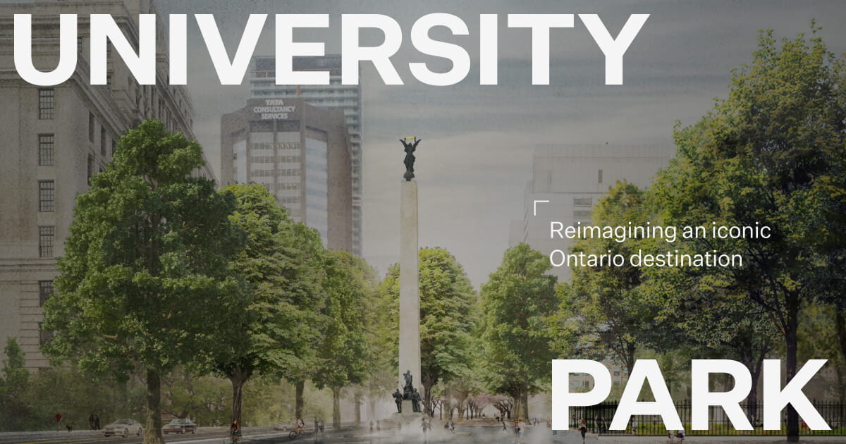
University Park
|
University Park is a visionary creation of green space along one of Toronto’s main streets. The plan is to take 9.5 acres on University Avenue, from Queen’s Park to the Waterfront and eliminate half of the existing street surface. Traffic lanes would be replaced with public plazas with pedestrian walkways, bike lanes, landscaping and trees.
The roadway on Queens Park Crescent West would be removed, Taddle Creek would be restored and walkways in Queen’s Park would be improved. The eastbound lanes south of College Street to Front Street would be converted to pedestrian walkways, bike lanes and greenery/landscaping. In June 2023, City Council accepted a donation from the Matthews Foundation and the Michael Young Family Foundation to pay for the costs of a Municipal Class Environmental Assessment, preliminary design and related studies for University Park. The initial area is from Hoskin Street (Queen's Park Crescent West) to College Street. The City is investigating sponsorship opportunities for the next area on University Avenue from College Street to Adelaide Street. If you are interested in more details visit universitypark.evergreen.ca/ or myff.ca/university-park/. |
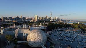
Ontario Place
|
We support Ontario Place for All, an advocacy group, in their fight to keep public access and use for the provincial government's proposed redevelopment of Ontario Place. Please visit their website ontarioplaceforall.com/ for more details. On August 16th, they hosted a panel discussion with Ken Greenberg: Urban designer, former Director of Urban Design and Architecture for the City of Toronto, Principal of Greenberg Consultants; David Crombie: Former mayor of Toronto 1972-87, president and CEO of the Canadian Urban Institute; Shirley Blumberg: Founding partner of KPMB Architects; Lesley Lewis: CEO of the Ontario Science Centre from 1998-2014; and Jason Ash: Co-founder and co-chair of Save Our Science Centre. You can view the discussion at https://ontarioplaceforall.com/abetteridea/.
The proposed Therme spa is an inappropriate use for prime waterfront property. The 13 storey glass building will be a death trap to the thousands of migrating songbirds who pass by the site every spring and fall. The building will also block the sightlines of hundreds of thousands of Torontonians. It does not seem environmentally or fiscally responsible for taxpayers to fund $650M to build over 2,000 underground parking spaces for a commercial business, whose 95 year lease has been kept secret from the public. The spa is in direct contravention of the City of Toronto’s Central Waterfront Secondary Plan to remove barriers, create spectacular waterfront parks in an environmentally responsible way. The loss of almost 850 mature trees which is a wildlife habitat for over 185 bird species is an insult to environmental efforts and disrespects the land which was occupied by the Petun, the Huron Wendat, the Haundenosaunee, the Mississaugas of the Credit and the Chippewa peoples for thousands of years. Ontario Place was designated a Provincial Heritage Property of Provincial Significance in 2013 and was added to the City of Toronto’s Heritage Register in 2019. It is an innovative architectural gem of the late twentieth century modernism style that is unique and became a travel destination for locals and tourists alike. Individuals and families alike mourn the closing of the Ontario Place amusement park in 2012 and the Cinesphere in 2022. Fitness enthusiasts were surprised by the sudden barriers to the parklands in 2023 that blocked access to valuable and rare green space in the urban city core. Music lovers at least continue to enjoy concerts at the Budweiser Stage. Ontario Place is an extraordinary jewel that should be available to all Ontarians, not just wealthy spa customers. A spa can be located anywhere and it should not be at Ontario Place. It should be parklands, alongside the concert venue. The legacy of Ontario Place should be a place for free fun, fitness and music for residents and visitors alike. |
|
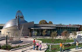
Ontario Science Centre
|
The Bay Cloverhill Community Association, which represents the residents of a small densely populated area in the downtown core, believes the Ontario Science Centre, an iconic building, should remain in its present location and not be moved to Ontario Place. Around the world, iconic buildings are retained and honoured and visited by millions of people.
The planning for the Ontario Science Center was started in 1961 under Premier John Robards as a centennial project, originally called the Centennial Center of Science and Technology. The renowned architect Raymond Moriyama was hired to design the centre at its current location. It consists of three buildings in a Brutalist design connected by a series of bridges and escalators, and set in a 100 acre parkland. Construction commenced in 1966 with plans to open in 1967 in time for the centennial celebration. The center was finally opened to the public in September 1969. The Center was a pioneer for its hands-on approach. Unlike a traditional museum, where exhibits are for viewing, the majority of the exhibits are interactive. Many others are live demonstrations. The exhibits are loved by children and adults alike and opens their eyes to the field of science. This is indeed important today in our fast changing world. Over the years thousands of adults, children and grandchildren have visited the center. We must preserve this building as part of our heritage. The location is indeed spectacular and could not possibly be replicated at Ontario Place. The centre provides employment and education opportunities to the residents of Flemington Park and Thorncliffe Park. It is also a cultural district which includes the Aga Khan Museum. There is not the space to provide the many exhibits that are in the current building. The opening of the Eglinton Crosstown’s Science Centre station will make the attraction even more accessible to the entire city. Locating the Science Centre to an already busy area would discourage visitors. In conclusion, we stress that the Ontario Science Centre remain in its current location. |
Avenue Road
|
Redesigning our major arterial roads to prioritize pedestrian and cyclist safety is important. Planning is underway to reduce the six vehicle driving lanes on Avenue Road between St. Clair Avenue West and Bloor Street to four lanes, installing bicycle lanes, wider sidewalks and drop off zones/street parking. This project would dovetail into similar improvements along Queen's Park Crescent/University Avenue, south of Bloor Street.
The City of Toronto is in the progress of completing an Avenue Road Study. Phase 2 was released in February 2024 and will be presented to the Infrastructure and Environment Committee in Spring 2024. The project timeline is estimated to be 2034 or later. www.toronto.ca/community-people/get-involved/public-consultations/infrastructure-projects/avenue-road-study/ |

|
The following are public realm projects in the Bay Cloverhill neighbourhood that have been completed, or in process.
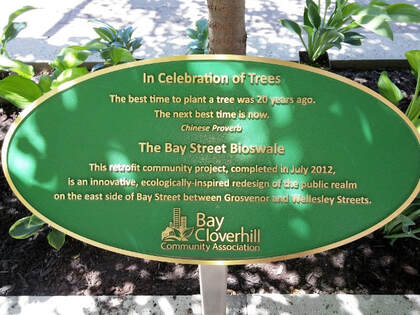
Bay Street Bioswale
|
The bioswale is a bioretention system under the sidewalk, on both sides of Bay Street between Grosvenor Street and Breadalbane Street. The underground Silva cells both treat stormwater and contain soil/space to allow the root system of trees to thrive. The original project cost $280,000 and was funded from Section 37/45 development contributions from 832/860 Bay Street and 825 Bay Street, as well as a grant from Live Green Toronto. It was completed in July 2012.
In addition to the many varieties of trees installed, annual flowers are planted. In 2020, you may have seen the special commemorative bright orange tulips to celebrate the 75th anniversary of Holland’s liberation by Canada’s military. The trees in the Bay Street bioswale are good for both people and the environment. In addition to making the city more attractive, trees reduce stress and promote physical activity. They promote healing and enhance community by promoting interaction. Trees reduce air pollution, provide oxygen, reduce the urban heat island effect, reduce stormwater runoff and provide a habitat for wildlife. |
|
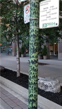
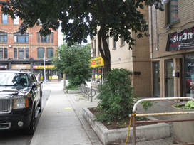
Hydro Pole WrapsYou may have noticed 63 hydro poles with a Boston ivy pattern wrap, on Bay Street from College Street to Charles Street. Not only is it nice to look at greenery rather than rusted hydro poles, the decorative laminate covers are also adhesive resistant, which discourages posters and graffiti.
|
|
Great White Oak Bench in Queen's Park
|
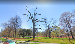
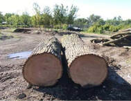
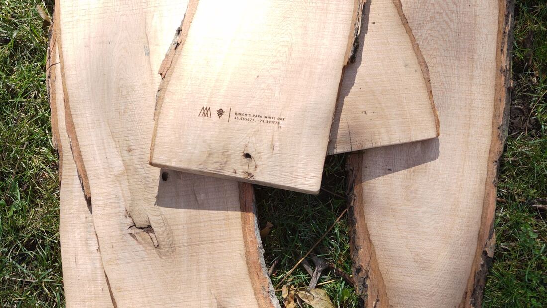
In November 2019, an 187 year old white oak in Queen's Park near the crosswalk to Victoria College was no longer sustainable. The wood from this tree has been reclaimed by cutting the tree trunk into 11 foot and 14 foot sections. Local firm 'Just Be Woodsy' used the larger tree trunk piece in the design for a 12 foot double sided bench for Queen's Park North. It was installed close to the original location of the tree on May 1, 2024. The design is inspired by Edward Lutyen's iconic Victorian age bench.
In addition, planks for the outdoor play area in Bishop Strachan School were created. |

Neighbourhood Walking Tours
Now you can explore Toronto with StrollTO tours available on their website at this link: StrollTO Bay Street Corridor. The Bay Cloverhill neighbourhood is included in the Bay Street Corridor tour, which features buildings such as Queen's Park, the mansions on Elmsley Place and the Native Child and Family Centre.
Jane's Walk is a neighbourhood walking tour program the first weekend of May each year to celebrate the birthday of urban activist Jane Jacobs. Walks can be in person or virtual. In 2023, "Facadism 2: Bloor-Yorkville-Yonge-College" highlighted building facades of architectural history and interest that have been preserved and integrated into new construction projects, including the Bloor Cloverhill neighbourhood. See our events page for details of 2024 walks, including "Clock Tower Trail". For more details, see www.janeswalkfestivalto.com/.
The possibility of enhancing the existing Uptown Toronto Discovery Walk to include the ‘green loop’ of park areas in the neighbourhood is being investigated.
The Clock Tower Trail pedestrian walking tour is under development, and provides a pathway through parks in the Bay Cloverhill, Church Wellesley and McGill Granby Village neighbourhoods. Art installations, historic landmarks and noteworthy buildings will be integrated into the walk.
Traffic Measures
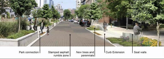
One of the BCCA’s goals are to create a pedestrian friendly environment by redesigning local streets to create a safe and spacious environment for residents to travel around the neighbourhood. There are plans in place to create a pedestrian priority area on Breadalbane Street, between Dr. Lillian McGregor Park and Opera Place Park. This work will be coordinated with the scheduled resurfacing of the street in 2025. Pedestrian connections will be improved with a green loop pedestrian crossing between Dr. Lillian McGregor Park and Opera Place Park, make safer crossings at Bay Street and Yonge Street intersections. In addition seat walls along the sidewalks will provide a place to rest. Traffic calming will be in place with curb extensions (bumpouts) to reduce vehicle speed and expand the sidewalk area. There will be a stamped asphalt 'rumble zone' surface that looks like brick to slow vehicles. Best of all green infrastructure will benefit resident's health and sustainability by capturing storm water capture to reduce flooding. New trees will be planted and existing tree pits will be expanded. More bicycle rings will be installed.
Proposed plan for Breadalbane Street
The opportunity to temporarily or permanently close the street to vehicular traffic in the future would be of benefit to pedestrians and cyclists. A similar possibility exists for St. Joseph Street, from Bay Street to Queen’s Park Crescent East, in conjunction with the upcoming Daniels development.

We worked with CentreCourt and the City of Toronto in the Fall of 2022 to enhance the curb expansion areas on St. Joseph Street at Bay Street and Yonge Street, by installing planters and barriers to enhance the existing bollards installed by the City of Toronto Transportation Department. These barriers are designed to discourage vehicles entering the one way street in the wrong direction, as well as reduce vehicle speed in the residential area.
In 2024, additional improvements will be made as part of the Toronto Centre Participatory Budgeting program.
In 2024, additional improvements will be made as part of the Toronto Centre Participatory Budgeting program.

The intersection of Dr. Emily Stowe Way and Grenville Street is being redesigned as part of road resurfacing, with work scheduled to start in Fall 2024. The existing island and right turn channel will be converted into an expanded sidewalk that will include new seat walls, reconfigured bike racks and a new BikeShare station. In addition, 3 new oak trees will be planted in a bioswale combined with permeable pavers that will divert rain water. These changes will improve the street level experience for pedestrians and cyclists, enhancing safety in line with the City's Vision Zero program.
Discussions are underway to brick part of St. Mary Street while increasing sidewalk space for pedestrians, which will encourage vehicles to drive slower and more carefully. This work is being coordinated with Canderel and will provide a direct view to the beautiful arched gateway entrance to Victoria College.
New traffic lights were installed at Grenville and Bay in early 2021. Another set of traffic lights were activated at St. Mary and Bay in November 2021. New traffic lights are scheduled to be installed in 2024 on Yonge Street at both Breadalbane Street and Grenville Street.
We are advocating to install a pedestrian crosswalk on the busy Queen's Park Avenue near Hart House. Pedestrian crosswalks are also proposed for Wellesley Street West midblock between Yonge Street and Bay Street to Dr. Lillian McGregor Park, Yonge Street at St. Joseph Street to the Dundonald entrance to the Wellesley TTC subway station, and Yonge Street between College Park and Aura Condos to Granby Street, as part of the Clock Tower Trail route.
Yonge Street Revitalization
The City of Toronto has launched the ‘yonge TOmorrow’ program to recommend ways to increase and improve pedestrian space on Yonge Street between College Street/Carlton Street and Queen Street. The recommended plan has pedestrian priority with one way driving access and cycle tracks. The design elements are being finalized and construction is expected to start in 2025. The next phase of the plan will be Yonge Street from between Bloor Street and College Street/Carlton Street. Planning for the second phase is underway and estimated to start in 2024 or 2025. www.yongetomorrow.ca
The ActiveTO Midtown Complete Streets project covers Yonge Street from Davisville Avenue to Bloor Street. It was a temporary project that installed protected bicycle lanes and allowed on street/curbside patios in April 2021, as part of pandemic recovery efforts. The project was extended in 2022, due to the success in increased pedestrian and cyclist traffic, with a minimal increase in vehicular traffic times. In February 2023, City Council voted to make the temporary project a permanent fixture.
https://www.toronto.ca/community-people/get-involved/public-consultations/infrastructure-projects/activeto-midtown-complete-street-pilot-project/
Street Signs
In February 2016, the inaugural Bay Cloverhill neighbourhood street signs were installed to identify the community. A total of 51 signs were put in place to help identify the Bay Cloverhill area. The logo on the signs was designed by artist Carol Westcott to reflect the sustainable orientation of the Bay Cloverhill Community Association and the mixture of buildings located in the area.
Neighbourhood Lanes
There are many lanes in the area that contribute to the quaint residential feel of the neighbourhood and connect main to secondary streets.
In 2007, several lanes were named. St. Basil Lane commemorated the adjacent St. Basil Seminary and The Order of St. Basil, whose international headquarters are on St. Joseph Street. St. Vincent Lane was designated after the tiny track that ran north of Grosvenor Street prior to the creation of Bay Street in 1922. Terauley Lane was termed to honour the original name of Bay Street in 2007. Terauley Street ran south from Grenville Street prior to the reconfiguration of Bay Street in 1922.
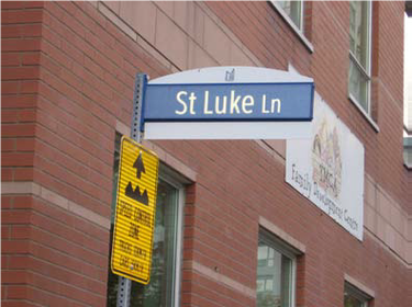
In 2008, St. Luke Lane was named after St. Luke's Church. It was demolished in the early 1900's to accommodate the construction of Bay Street, which replaced Chapel Street. The Ontario Chrysler car dealership was then built, and replaced by 1001 Bay condominium building in 1988.
In 2009, Cottage Lane was selected in honour of the 10 Victorian cottages that are adjacent to the lane.
In 2013, a portion of Elizabeth Street was renamed Emily Stowe Way in honour of the first female doctor in Canada.
In 2019, the small lane north of Wellesley, west of Yonge was named Bistro Lane, to commemorate well known bistros over the past 40 years, such as Bistro 990 and Segovia, that have closed and been replaced by condominium buildings. La Scala Lane was named after the famous Italian restaurant that was located at the southeast corner of Bay and Charles from 1962 to 1993.
Other small streets in the neighbourhood include Inkerman Street, Phipps Street, and Elmsley Place.
In 2007, several lanes were named. St. Basil Lane commemorated the adjacent St. Basil Seminary and The Order of St. Basil, whose international headquarters are on St. Joseph Street. St. Vincent Lane was designated after the tiny track that ran north of Grosvenor Street prior to the creation of Bay Street in 1922. Terauley Lane was termed to honour the original name of Bay Street in 2007. Terauley Street ran south from Grenville Street prior to the reconfiguration of Bay Street in 1922.
In 2008, St. Luke Lane was named after St. Luke's Church. It was demolished in the early 1900's to accommodate the construction of Bay Street, which replaced Chapel Street. The Ontario Chrysler car dealership was then built, and replaced by 1001 Bay condominium building in 1988.
In 2009, Cottage Lane was selected in honour of the 10 Victorian cottages that are adjacent to the lane.
In 2013, a portion of Elizabeth Street was renamed Emily Stowe Way in honour of the first female doctor in Canada.
In 2019, the small lane north of Wellesley, west of Yonge was named Bistro Lane, to commemorate well known bistros over the past 40 years, such as Bistro 990 and Segovia, that have closed and been replaced by condominium buildings. La Scala Lane was named after the famous Italian restaurant that was located at the southeast corner of Bay and Charles from 1962 to 1993.
Other small streets in the neighbourhood include Inkerman Street, Phipps Street, and Elmsley Place.
Museum Station Accessibility Improvements

A mandatory secondary exit in Queen's Park North opened in May 2024 for the Museum TTC Station on University and Bloor. In addition, all TTC stations must be made accessible, which requires the installation of an elevator from the street level to the Museum Station subway platform. Lane restrictions on Queen's Park Crescent are in place during the construction, including temporary closure of the bike lanes. Work is underway on the elevator and estimated completion is before the end of 2025.
Traffic Control Signal Box and Telephone Box Artwork
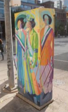
We strive to beautify the neighbourhood where ever possible. Traffic signals are controlled with typically grey cabinets installed on the sidewalk, but you will notice that some have been artfully decorated. The same goes for the Bell telephone utility boxes, also located on sidewalks, as part of the Out of the Box mural art program. You will see green hydro boxes scattered about the neighbourhood, but unfortunately these are excluded from the artwork programs.
In 2016, artist Jacqueline Comrie painted this traffic signal box at College and Elizabeth Streets called "March of the Suffragettes".
In 2016, artist Jacqueline Comrie painted this traffic signal box at College and Elizabeth Streets called "March of the Suffragettes".
Community Gardens
The amount of concrete in downtown neighbourhoods can be overwhelming. To add some greenery and character, we have a dedicated team of volunteers who maintain community gardens located on the following streets:
- Irwin Street
- (south side, west of Yonge Street)
- Created in 2009, a ‘chat corner’ was created beside the commercial building at 644 Yonge Street. Concrete planters with trees and shrubs, a bench and bicycle parking replaced the commercial boulevard vehicle parking that was being eliminated by the City to improve pedestrian safety as part of the Vision Zero program.

St. Mary Street
(north side, between La Scala Lane and St. Nicholas Street)
Adjacent to the U of T Student Family Housing apartment building playground at 35 Charles Street, colourful flowers and greenery provide a calming background for the street benches.
(north side, between La Scala Lane and St. Nicholas Street)
Adjacent to the U of T Student Family Housing apartment building playground at 35 Charles Street, colourful flowers and greenery provide a calming background for the street benches.

St. Joseph Street
(north side, east of Bay Street)
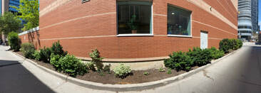
In front of the Polo II condo building, there are expansive brick and wood planters containing trees, shrubs and ground cover, edged with seating areas. These gardens were created in 1988 when the adjacent condo building was being constructed. Perennial plants that flower at different times of year provide greenery all year round. The honey locust trees provide light shade on warm days.
(north side, east of Bay Street)
In front of the Polo II condo building, there are expansive brick and wood planters containing trees, shrubs and ground cover, edged with seating areas. These gardens were created in 1988 when the adjacent condo building was being constructed. Perennial plants that flower at different times of year provide greenery all year round. The honey locust trees provide light shade on warm days.
St. Basil Lane
(west of Bay Street, north of Wellesley Street)
On either side of this quiet lane, the transition between condominium and office buildings into Basilian Brothers/University of Toronto buildings is softened with trees and shrubs. Some plants and shrubs were reclaimed when the U Condos sales office that was located on the site of Clover Hill Park was decommissioned.
St. Luke Lane
(west side, west of Yonge Street, north of Grosvenor Street)
Behind the YMCA Family Development building at 15 Breadalbane, the lane is enlivened with green shrubs.
(west side, west of Yonge Street, north of Grosvenor Street)
Behind the YMCA Family Development building at 15 Breadalbane, the lane is enlivened with green shrubs.
Outdoor Murals

Selected as a Toronto Centre Participatory Budgeting project in 2023, plans are underway to install outdoor art murals on the west facades of the buildings at 530 Yonge Street/8 Breadalbane and 145 St. Luke Lane, adjacent to Dr. Lillian McGregor Park. Artwork on the side of the building facing the park would animate the laneway and would improve the view from the park and children's playground. The theme could reflect the indigenous design of the park, area history, or the current businesses in the building. The project was approved by City Council in March 2024. There are issues with the 530 Yonge Street building, so the project will be relocated to the adjacent building at 556 Yonge Street. Planning is underway lead by STEPS Public Art who will be consulting with members of the public and curating art, with completion in 2024.
Tree Planters

Another project for Toronto Centre Participatory Budgeting chosen in 2023, is the installation of new tree planters along St. Nicholas Street and Irwin Street. The existing trees provide a lovely canopy along the endearing St. Nicholas Street between Irwin Avenue and St. Mary Street, as well as Irwin Avenue, west of St. Nicholas Street. However the planters are at grade and do no protect the existing trees and plants. Planning is underway with completion in 2025.